
I had an occasion to visit this monument recently, so I thought “Hey, we desperately need yet another crazy idea about its significance!”, so here we go…
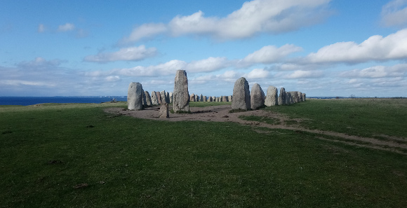
It is Ales Stenar — the Stones of Ale, a stone ship near Kåseberga in Southeastern Scania. Kås- means haven/harbour in Scanian, or pier/jetty. In this case probably a natural haven as the piers were constructed in ca 1882 and the name of the village is attested from at least year 1545.
Kåseberga would be the most natural place on the Scandinavian peninsula to stock up before leaving for continental Europe. When navigating the seas before GIS (GPS, Glonas, Baidu, et c) a basic tactic is to follow a coast whenever possible. As soon as you are on open sea with no land in sight you will have to rely on the stars to keep the course straight and that is more difficult and less exact. So you would want to cross a sea, such as in this case the Baltic Sea, where there is as much land as possible to guide you.
As it happens, outside Kåseberga the island Bornholm guides the sailor halfway to Poland and provides a convenient crossing. After passing through open sea, you would also want a wide stretch of coast to catch you so you cannot miss it. In order to reach the river Vistula, the green route can be sailed; and in order to reach the mouth of Oder, the violet route in this map*:
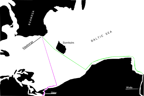
If you place yourself with the back against that large stone in the first picture, and use the smaller stone for sighting, the direction you get is the violet line in the map.
How about the green line?
Jordanes Getica
In chapter 3 we read (and I quote Charles Christopher Mierow’s English translation along the Latin text):
Ad Scandziæ insulæ situm, quod superius reliquimus, redeamus.
Let us now return to the site of the island of Scandza, which we left above.
De hac etenim in secundo sui operis libro Claudius Ptolomeus, orbis terræ discriptor egregius, meminit dicens:
Claudius Ptolemæus, an excellent describer of the world, has made mention of it in the second book of his work, saying:
Est in Oceani Arctoi salo posita insula magna, nomine Scandza, in modum folii cetri, lateribus pandis, per longum ducta concludens se.
“There is a great island situated in the surge of the northern Ocean, Scandza by name, in the shape of a juniper leaf with bulging sides which taper to a point at a long end.”
This is a bit weird. For if we look in book 2 of Ptolemaios’ Geographike Hypegesis, he does mention, not Scandza but Scandia, and nothing about juniper leaves. Ptolemaios has coordinates for the western, northern, eastern and southern edges of Scandia, but claims to know next to nothing about the shape of this supposed island, which satellites reveal is actually a peninsula. Jordanes continues:
[…] Haec a fronte posita est Vistulæ Fluminis, qui Sarmaticis montibus ortus in conspectu Scandzæ septentrionali Oceano trisculus inlabitur, Germaniam Scythiamque disterminans.
[…] This island lies in front of the river Vistula, which rises in the Sarmatian mountains and flows through its triple mouth into the northern Ocean in sight of Scandza, separating Germany and Scythia.
Ptolemaios’ Geography
Here is Ptolemaios (my own sloppy translation, and without the special characters for coordinates in Greek):
Ἀπ’ ἀνατολῶν δὲ τῆς Κιμβρικῆς Χερσονήσου τέσσαρες νῆσοι αἱ καλούμεναι Σκανδίαι, τρεῖς μέν μικραὶ, ὧν ἡ μέση ἐπέχει μοίρας: …
East from the Cimbrian Peninsula, four islands called Scandie, three small [ones], of which the centre is located: 41° 30′, 58°.
μία δὲ μεγίστη καὶ ἀνατολικωτάτη κατὰ τὰς ἐκβολὰς τοῦ Οὐιστούλα Ποταμοῦ, ἧς τὸ μὲν δυτικώτατον πέρας ἐπέχει μοίρας: …
and one largest and most eastern down/at/by the outlet of Vistula River, whose westernmost edge is located: 43°, 58°
τὸ δ’ ἀνατολικώτατον
the east 46°, 58°
τὸ δ’ ἀρκτικώτατον
the north 44° 30′, 58° 30′
τὸ δ’ μεσημβρινόν
the south 45°, 57° 40′
Καλεῖται δὲ ἰδίως καὶ αὐτὴ Σκανδία, καὶ κατέχουσιν αὐτῆς τὰ μὲν δυτικὰ Χαιδεινοὶ, τὰ δ’ ἀνατολικὰ Φαυόναι καὶ Φιραῖσοι, τὰ δὲ ἀρκτικὰ Φίννοι, τὰ δὲ μεσημβρινὰ Γοῦται καὶ Δαυκίωνες, τὰ δὲ μέσα Λευῶνοι.
Individually it is itself called Skandia, and its western part is possesed by Hedini, the eastern by Fayoni and Firesi, the north by Finni, the south by Guti and Daycions, the midlands by Leyoni.
But …
In the preface to Getica, Jordanes explains that the book is based on a 12 volume history written by Senator [Cassiodorus]. Unfortunately, the books were not available to him, so he had to rely on his memory.
Since Getika is a detailed and mostly reliable historical account, he probably used other written sources besides his memory, yet there is an obvious possibility that he may have gotten some details wrong.
One such detail, obviously is the fact that Scandza/Scandia is not within sight from the outlet of Vistula (on modern maps often referred by its polish name Wisła). Yet Jordanes couldn’t possibly have invented that fact, so the work by Cassiodorus probably contained a statement to the effect that something was in sight of something else.
Another observation is that it is usually very hard to tell what shape an island has. For this reason, the statement that Scandza was the shape of a juniper leaf is confusing. How did they know and, if some very smart filosopher had found out, what use would that information be to a ship’s crew, just seing a coastline?
I can think of one special case when this info would be useful: if you stand on top of a hill or mountain, overlooking a sea with relatively small islands in it, planning where to go next. I suggest therefor that the instruction to look for an island in the shape of a juniper leaf, which is within sight, was directed to a traveller starting at Kåseberga, Scandza and going towards the Roman Empire.
Here is a comparison of Bornholm, sighted from Ales Stenar, with a juniper needle from the speices which is common in Scania.

Why is this a crazy idea? Because there is actually a juniper needle shaped island just 25 km outside the outlet of Vistula. It is named Hel, and if you sail along its north-eastern coast, then keep a straight course, you will eventually get to Scandza, albeit with a 250 km passage across open sea instead of just 100 km. Pray for good weather!
* Maps displayed on this site may not be used for navigation. Use real nautical charts.